• The SBOING way of
    NAVIGATION!
    Check out our GPS ultimate navigation mobile app.
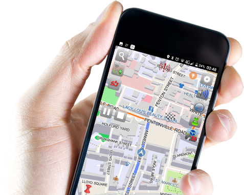
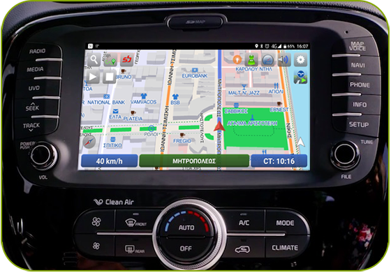
    UltiNavi
  • Available for car
    UltiCarNavi™
    Specially tailored for in-car consoles
  • Innovative & collaborative technology
    SBOING.NET
    More accurate routing & faster map updates

Unlock all of SBOING capabilities with our Ultimate Navigator App It's easy to use and completely free.

SBOING = innovative collaborative "navigation beyond"

SBOING.NET is an innovative, collaborative Web-2.0 / Web-3.0 technology for the collection, processing and distribution of traffic data to provide improved routing capabilities for GPS navigation.

Users record their routes and exchange them with free navigation software and world maps, utilizing a credit-based system. After sophisticated processing of the user traces and other contributions, SBOING maintains an active database of traffic data for the entire planet and uses it to perform more accurate routing and offer faster map updates for its users and other GPS-navigation applications.


The "New Navi-Pedia"


How does it work?

register Register
record Record
upload Upload Traces
  • earn SCUs
  • SBOING special offers
Unlock Special Offers

SBOING™ works in 5 easy steps:

  1. Get the FREE SBOING™ navigation app
  2. Record traces, while driving around
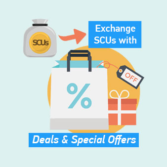
  3. Upload your traces and earn credit ("Sboing Credit Units", or SCU)
  4. Turn your accumulated credit into money savings by unlocking special deals and offers.
  5. Use FREE SBOING™ navigation app to read SBOING™ maps with frequent updates and NO ads.

SBOING Special Offers

There are no special offers at the moment


The SBOING™ concept

  • Today’s Portable Navigation Devices (PNDs), based on GPS receivers and using static maps are updated at relatively regular intervals, with or without a subscription service. These maps are based almost entirely on static data and, although they are updated periodically by their vendors, their use has several drawbacks, including: - Costly map upgrades (after the initial free offer of the service) - Lack of details and new information - Lack of dynamic data (e.g., traffic conditions on certain days and times of day, traffic lights and waiting time for them, etc.).

The SBOING™ methodology

  • Instead of the static speed limit of a road used by today’s navigators, the SBOING technology is based on a collaborative methodology, which consists of the statistical recording, for each road section, of the average travelling time for every vehicle type, weather conditions, day of the week and time of day. Thus, for example, for a 100m section of road XYZ average travel time may be 40 sec., on Tuesday afternoon, or 15 sec., on Sunday morning, etc.
  • While driving, the GPS unit records and stores a number of parameters, including the vehicle’s GPS position (GPS coordinates), velocity, altimeter and timestamp.
  • The user subsequently uploads its collected traces to the SBOING web-site and in return (s)he gets updated maps for its PNDs, through a “credit-debit” system (based on credit units, which are called SBOING Credit Units, or SCUs).
  • The uploaded data undergoes certain statistical validity checks, carried out by the SBOING backend, (to filter out any malicious or invalid data) and it is statistically integrated inside SBOING’s database and world maps.
  • Based on its collected credit units, each user can unlock money saving deals and special offers, through SBOING’s web-site.

Our technology advantages

The time-variant data, collected and used according to the SBOING technology:

  • Lead to more accurate routing decisions compared to existing commercial PNDs, which are based on static traffic information (e.g., the speed limit, etc.),
  • Do not require special facilities, infrastructures, or other external information sources (e.g., street sensors, references of active mobile phone densities, etc.),
  • Produce more accurate results than other methods which cannot accurately distinguish and isolate data traffic on specific roads or on small roads,
  • Have an inherent, independent mechanism: a) to produce new maps (for uncharted areas), and b) for self-updating of existing maps,
  • Are able to distinguish and provide accurate routing instructions, depending on the type of vehicle (e.g., pedestrian, fast / slow motorcycle, fast / slow car, truck, bus, taxi), weather and corresponding road conditions (sun, rain, snow, etc.).
  • Have better scalability properties, compared to other real-time approaches, as it is worldwide in scope. Most other approaches rely on tracking only certain roads due to practical constraints and to the high cost of establishing the proper sensor infrastructure for the data collection,
  • Are compatible technology with all existing PNDs,
  • Have an ecological and socio-economic dimension (reducing fuel consumption, pollution, traffic congestion, etc.).

SBOING memberships